I’m proud to release the below four-part article focusing on Women’s Safety and Welfare within the Geotechnical and Geoenvironmental Industry. The article coincides with International Women’s Day (IWD) – celebrated annually on the 8th March – so we want to raise awareness of ongoing issues Women encounter, what’s being done and what we can do to be more inclusive. I’ve been lucky to be supported in this article by four incredible women covering different aspects of the topic. If you would like to contact any of the writers, their emails have been included in their biography section. Bradley Falcus, Principal Administrator, Central Alliance

Hollie Taylor, an Engineer at Amey, is working to ensure that Women’s PPE is a workplace essential in Amey and subsequently, the wider community. Her work has been celebrated at the GE Awards and Inspiring Women in Construction & Engineering Awards in 2024. In this article Hollie will cover the topic of the importance of Women’s PPE in Construction and Engineering.
Contact: hollie.taylor@amey.co.uk
The conversation around workplace safety has evolved to include a critical aspect that was often overlooked: the need for personal protective equipment (PPE) designed specifically for women. As more women are encouraged to enter construction and engineering fields, the demand for PPE that fits and protects them adequately has become increasingly urgent. This article explores why women’s PPE is crucial for ensuring safety, comfort, and equality in these industries.
One of the primary reasons women’s PPE is essential is the significant difference in body shapes and sizes between men and women. Standard PPE is typically designed based on male body dimensions, which can lead to ill-fitting equipment for women. For instance, oversized gloves can reduce dexterity, loose helmets can impair vision, and baggy coveralls can become tripping hazards.
Comfort is a critical factor in ensuring that workers consistently use their PPE. Ill-fitting equipment can cause discomfort, leading to workers removing or adjusting their PPE, which compromises their safety. Women-specific PPE is designed to accommodate the unique anatomical features of women, such as narrower shoulders, shorter torso lengths, and different hand shapes. By providing PPE that fits well and is comfortable, employers can enhance compliance with safety protocols, ensuring that all workers are adequately protected at all times.
The availability of women’s PPE is also a matter of equality and inclusion. When women are provided with PPE that does not fit properly, it sends a message that their safety and comfort are not as important as their male counterparts. By investing in women’s PPE, employers demonstrate their commitment to creating an inclusive work environment where all employees are valued and their safety is prioritized. This can improve morale, job satisfaction, and retention rates among female employees.
Within Amey, we wanted to truly understand our employees’ needs, so we decided to go straight to the source. We asked our female employees for their feedback on how well our current suppliers’ PPE fits and their thoughts on the availability of women-specific options. Additionally, we inquired about how different stages of their menstrual health cycle might affect the fit of their PPE.
Reviewing the feedback generated from the survey identified specific areas of focus for our Suppliers. Primary focus was for increased range and fit. This led to the initiation of working groups to help the suppliers trial their existing PPE ranges.
Collaborative work like this is important for the industry to ensure adequate PPE is provided that meets the unique requirements of women, ensuring that all workers are safe, comfortable, and valued. By doing so, we can create a safer and more inclusive work environment for everyone.
 Katherine Evans, a chartered geologist with an extensive technical mining background, is dedicated to raising awareness and helping businesses to improve equity for women in construction, engineering and mining. Katherine is the founder of Bold as Brass, a tribe of likeminded women and allies fighting for gender equality in and out of the workplace. Katherine shares her take on psychosocial safety of women in the industry covering taboo topics, usually not discussed.
Contact: katherine@bold-as-brass.com
Unless you’ve hyper focused the building blocks of the skills shortage problem, you may not have reached this conclusion – businesses are still creating workplace environments and career trajectories to serve outdated traditional workforces made up entirely of average sized, average weight, non-religious, able bodied, heterosexual, cis-gender, Caucasian, males of full health with short back and sides – in reality, a very small demographic of people to have ever existed.
I hold an unpopular opinion – I don’t believe it’s on purpose; I have far too much faith in people for that, but I’ve experienced enough human-imposed trauma to know outliers exist so don’t wish to downplay anyone’s pain. I don’t believe the decision makers of industry, on the whole, intentionally push aside people of already marginalised communities for the better of their own, but I do believe the demographic of decision makers is not diverse enough to understand how their decisions affect all people.
It’s so important to realise this isn’t only a gender issue, but because women make up 51% of the population, fixing this issue would result in a chunky change. To rectify it though we need to get real, we need to acknowledge, understand, and work with not dismiss intersections. Not all women are treated equally, not all women are the same, not all women were assigned female at birth, and not all men are without uteruses. If you just muttered woke, awesome, I feel seen.
Femininity isn’t fragility, being masculine isn’t toxic; vulnerability is the result of other’s wishing to take advantage; sharing a vehicle with someone you don’t know can be both dangerous and terrifying, even if you work for the same company; hotels aren’t universally safe.
Black women are four times more likely than white women to die during childbirth in the UK because of the racist society we live in; 1 in 5 birthing parents in the UK experiences birth trauma, I’m one of them; a second-, third-, or fourth-degree tear may change a birthing parent’s ability to poo forever; 40% of women and 10% of men suffer with incontinence.
Period blood isn’t just blood, it’s made up of stem cells, the type that can change into any other cell in the human body – how amazing is that?; males have a testosterone cycle that repeat each day and a their own menopause, it’s called andropause; studies have found 200,000 bacteria per square inch on public toilet floors; bacteria on hands when changing period products can be pushed into the vaginal cavity where it can multiply and result in sepsis, or release toxins that can lead to toxic shock syndrome, both of which kill people.
The hips exit the female pelvis at a higher angle than the male, making the weight distribution and pressure on the knees different to that experienced by males, and also increasing the likelihood of knee injury in females. The female foot is narrower than the male, female toes point outwards whereas male toes point inwards.
The female foot, generally, has a higher instep and higher arch than the male, although my husband’s is far more arched than mine – we are still natural beings with multiple variations; diabetic people shouldn’t wear waterproof footwear because the fabrics cause sweat to stay inside the shoe; male ankles, generally are wider than the female so male fit boots don’t tie tight enough around a female ankle and that can result in the foot completely lifting out, or rubbing leading to laceration of the skin, or tripping because of the inability to balance on a moving surface – being the boot itself, aka. anti-safety safety equipment.
There is so much more to assessing risk than using our own experiences and our personal perceptions of reality. But we can do this. Consult with your teammates who are members of marginalised communities and apply their thoughts around safety to what has always been, as well as going down a rabbit hole of research on how gender is affected by intersections, because you don’t want to be that person who forces someone else to relive trauma for the purpose of your education.
 Charity Rose is an Engineering Geologist based in the Ground Engineering and Tunnelling sector of AtkinsRealis. Charity has a record of advancing the provision of welfare facilities for all on site, challenging HSE to ensure that adequate facilities for Women are enshrined in legislation and pushing employers to follow the guidance provided. Charity has kindly shared with us what employers and individuals can do to be inclusive of all on site.
Contact: Charity.Rose@atkinsrealis.com
As mentioned in Katherine’s article, the UK’s engineering and construction sector is currently facing a shortage of skilled workers. Despite efforts to encourage a culture of equality and inclusion across the industry, women remain underrepresented, accounting for only 13 % of construction workers.
When it comes to culture, a diverse workforce is integral to creating an improved sense of community, increased worker engagement, and creating role models. It is important to retain women already working in the industry as well as recruiting more. A total of 47% of female constructions workers have never worked with a female manager, and it is difficult to be what you can’t see. There is a strong business case for a diverse workforce. Companies in the top quartile for gender diversity are 15% more likely to have financial returns above industry medians.
A barrier women state as stopping them progressing or continuing working within the construction sector is a lack of access to appropriate welfare facilities. Women commonly complain that welfare units are locked from the outside, lack sanitary disposal facilities or are used as storage facilities for cleaning products such as brooms, mops and toilet rolls!
The majority of people believe they are ‘doing the right thing’ by keeping toilets locked. However, this is not the case as a locked toilet is not accessible. Having to find and ask a colleague for a key a further adds to a woman’s mental load. Additionally, it is not possible to “hold back” menstrual flow and being unable to change period products promptly in a clean space increases the risk of health conditions such as toxic shock syndrome. A total of 89% of people who menstruate have experienced stress or anxiety at work because of their period.
Improving welfare and access to welfare will go a long way in helping women to be safer and feel more welcome in the workplace. But what makes welfare ‘suitable and sufficient’?
In November 2022, HSE published the Construction Welfare Standards which state the basic expectations for compliance with Schedule 2 of the CDM Regulations.
The document clarifies that a toilet facility is deemed suitable and sufficient if there is a means to dispose of sanitary waste. Sanitary disposal facilities are inexpensive with the average cost of a serviced sanitary bin was less than £10 in 2023. The publication will hopefully encourage employees to ask for changes to be implemented as well as remind employers of their legal responsibilities.
In addition to following regulations, there are several actions employers and individuals can take to show they support women when it comes to welfare. A few suggestions include:
• Employers: Purchasing period products (such as tampons, and pads) and leave them in toilets to be used by employees. There are several period product companies which offer a subscription service but buying products from a local supermarket can be efficient for small businesses.
• Employers: Issuing Period packs. Despite recent clarification of regulations, change does take time. Employers can help individuals who menstruate by providing them with ‘Period Packs’. These are waterproof make up sized bags which include sanitary disposal bags, period products, tissues and hand sanitiser, empowering women to feel confident and comfortable on-site. Period packs can be viewed similar to first aid kits and can be taken to site by all individuals. AtkinsRealis have been trialling period packs and found them to be useful for people who menstruate as well as people who have incontinence or are diabetic and need somewhere to dispose of sharps.
• Employers: Menstruation and/or Menopause Accreditation is a formal achievement which demonstrates that companies are changing the lived experience for employees through their polices and a cultural shift.
• Individuals: Raise the issue internally. Talking about menstruation is difficult and can make people feel uncomfortable. However, the law is clear that sanitary disposal facilities are an essential part of welfare facilities and the few minutes it takes to pen an email could save hours of stress and embarrassment for you and/or your colleagues. Do not suffer in silence. If you want to connect with people in the industry who might have experienced similar issues then the ‘Bold as Brass Network’ and the ‘Bold as Brass Allies Group’ on LinkedIn are great places to start. If raising issues with your employer is unsuccessful then I encourage you to complain anonymously to HSE directly.
• Individuals: Be an ally. You do not have to be a person who menstruates to help improve welfare on construction sites. Reach out to your colleagues and ask if there is anything you can do to support them and call out unsafe behaviours. Additionally, if working on a site where toilets are not gender specific check to see if there are disposal facilities present – if not raise it with the appropriate party.
 Sarah Wilsher is a licensed Transformational Coach, Trainer, and Speaker specialising in Midlife, Menopause, and Menstrual Health. As a licensed Menopause Champion with the Menopause Experts Group, she is passionate about breaking the taboo surrounding these topics and creating lasting, positive change in the workplace and beyond.
With a 25-year career in the professional clothing industry, Sarah collaborates with workwear designers to ensure garments are designed with menopause and menstrual health in mind—prioritising safety, comfort, and inclusivity. She delivers tailored programs to raise awareness which are outlined at the end of this article.
Contact: sarah@sarahwilsher.com
Menopause is a natural biological transition marking the end of a woman’s reproductive years. Defined as 12 consecutive months without a period, it typically occurs between 45 and 55, with an average age of 51 in the UK. However, factors like genetics, surgery, or medical conditions can lead to early menopause or Premature Ovarian Insufficiency (POI), affecting 1% of women under 40 and 10-15% before age 45.
Perimenopause, the years leading up to menopause, is often the most symptomatic phase. Fluctuating oestrogen and progesterone levels impact everything from brain function and body temperature to collagen production, bone strength, and heart health. The decline of oestrogen can lead to skin and muscle loss of elasticity, increased fracture risk, and heightened fatigue. Meanwhile, reduced progesterone can cause anxiety, brain fog, and cognitive difficulties, all of which can affect workplace performance.
Menopause is not solely an age-related transition. Symptoms may impact the health, safety, and well-being of colleagues who don’t fit the stereotypical age of 50+. Understanding the 34 most common symptoms—including memory lapses, mood swings, fatigue, and loss of concentration—is crucial in fostering a supportive work environment.
Cognitive changes, such as memory lapses and difficulty concentrating, can affect job performance and decision-making. For women where precision and safety are paramount, these symptoms can lead to increased stress and a sense of uncertainty. Providing resources like training refreshers, peer support groups, and flexible work arrangements can help manage these challenges. Additionally, fostering a workplace culture that values open communication and understanding can alleviate the stigma surrounding cognitive symptoms.
Night sweats and heart palpitations can significantly disrupt sleep patterns, leading to fatigue and decreased productivity. This can translate to slower reaction times, reduced focus, and a higher risk of accidents. Employers can mitigate these risks by offering flexible schedules, ensuring adequate break times, and promoting access to health and wellness programs. Simple accommodations like a quieter rest area or access to hydration stations can also help people manage fatigue during demanding workdays.
Workwear is often designed with a one-size-fits-all approach, failing to account for the unique needs of a diverse workforce, and for people who menstruate or will experience menopause. Symptoms like hot flashes and bloating can make traditional uniforms uncomfortable and even unsafe, especially when working outdoors or in high-temperature environments. Employers can address this by collaborating with designers to create menopause-friendly garments—lightweight, breathable fabrics and adjustable fits can make a significant difference. Incorporating comfort panels and gussets in darker colours not only makes sensitive areas more comfortable, but removes the anxiety around leakage from heavy periods or stress incontinence. Incorporating PPE that aligns with these needs ensures both comfort and compliance with safety standards. I am proud of my involvement in the research and development of Inclusive PPE and am encouraged by the improved availability to suit a much more diverse workforce.
Hormonal fluctuations during menopause can cause mood swings, irritability, and emotional vulnerability. These changes can strain both personal and professional relationships, making it harder for women to navigate their roles effectively. Additionally, menopause often coincides with other life transitions, such as caring for aging parents or experiencing an empty nest, compounding the emotional strain. Educating colleagues about menopause through workshops or awareness campaigns can foster empathy and understanding, creating a more supportive environment. This inclusivity not only benefits those experiencing menopause but also strengthens team cohesion and morale.
Supporting people throughout the menopause transition isn’t just an ethical choice—it’s a smart business decision. Workplaces that embrace menopause-friendly policies tend to see higher employee satisfaction and retention rates, improved morale, and enhanced productivity. For the geotechnical and geoenvironmental sectors, where skilled labour is in high demand, retaining experienced workers is crucial. Moreover, fostering an inclusive culture signals to prospective employees that the company values diversity and well-being, making it an employer of choice.
Employers within the industry can take actionable steps to support menopausal women, ensuring their safety, wellbeing, and career progression:
1. Conduct Training and Awareness Programs: Educate employees at all levels about menopause to foster empathy and understanding. A variety of Lunch and Learn programs, Menopause Champion Training and Educational Resources are available from Sarah Wilsher Coaching Ltd – www.sarahwilsher.com
2. Redesign Workwear: Collaborate with designers to create comfortable, menopause-friendly uniforms and PPE.
3. Implement Flexible Policies: Allow for flexible scheduling, modified duties, and access to quiet spaces.
4. Promote Open Communication: Encourage a culture where women feel comfortable discussing their needs and seeking accommodations.
By addressing the unique challenges of menopause, employers can empower women to thrive in their roles, ensuring a safer, more inclusive, and productive workforce. Menopause is not a barrier—it’s a phase of life that, with the right support, can be navigated with confidence and resilience.


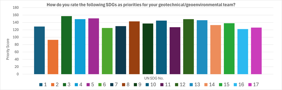
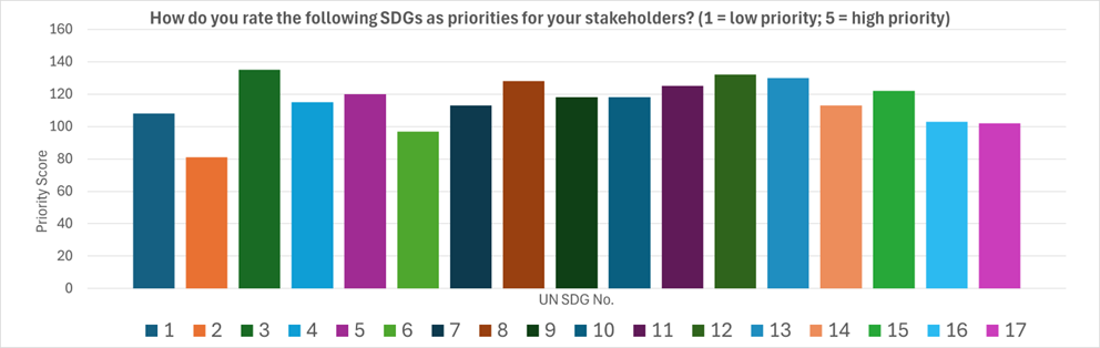
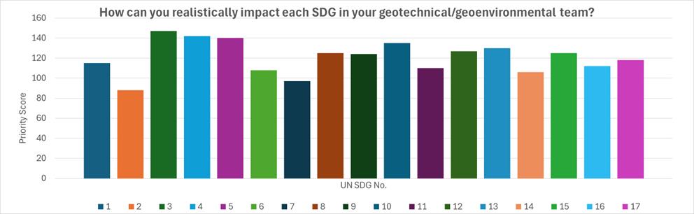
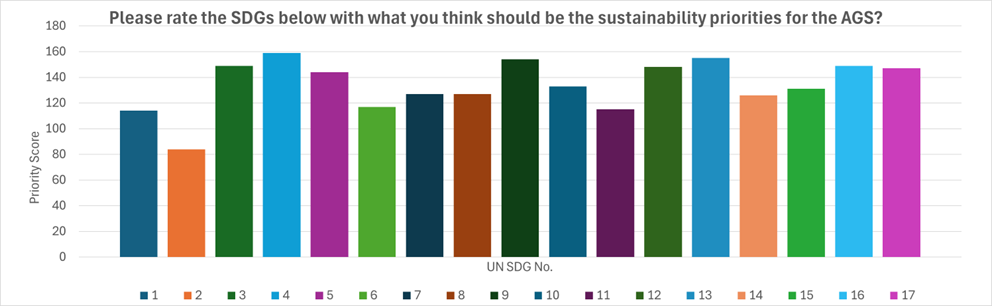
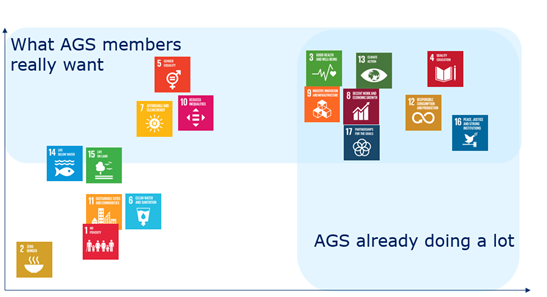
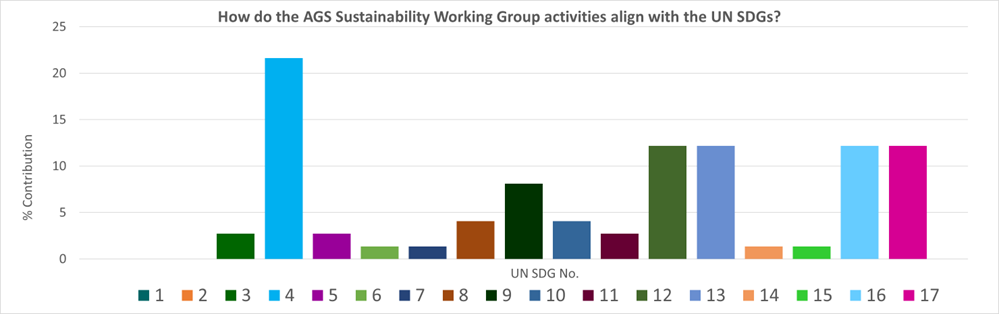 Figure 1: How do the AGS Sustainability Working Group activities align with the UN SDGs?