Overview
In May 2021 a SoBRA sub-committee was established to develop guidance to help practitioners in the land contamination sector to account for climate change effects in controlled water risk assessments (CWRA) in a robust and consistent manner. The sub-committee has representatives from geo-environmental consultancy and UK regulatory bodies (a full list of contributors is provided at the end of this article). The full guidance entitled “Guidance on assessing risk to controlled waters from UK land contamination under conditions of future climate change” (V.1.0, dated August 2022), will soon be available for download from the SoBRA website[1].
Context
Climate change is expected to alter the frequency and distribution of rainfall, increase atmospheric temperatures, and increase the frequency and severity of extreme weather events, leading to longer periods of drought and more extreme rainfall events with associated rising groundwater and surface water levels causing flooding and coastal inundation. Furthermore, long-term changes in climate are forecast with the Meteorological Office projecting that by 2070, on average across the UK, summers will be between 0.9 and 5.4 ᵒC warmer, and winters will be between 0.7 and 4.2 ᵒC warmer[2]. Precipitation is also expected to be affected, with a -47% to +2% UK average change during the summer months, and a -1% to +35% change during winter months[3]. The projected pattern of rainfall across the UK is not uniform and will continue to vary on seasonal and regional scales into the future – see information provided by the Met Office[4] for seasonal and regional variations.
Changes in recharge rates, and to a lesser extent atmospheric temperature, can be important factors in determining the outcome of CWRAs[5] being completed to assess the impacts to receptors from contaminant sources. Climate change could therefore alter the risk posed to controlled waters (including to groundwater resources, surface water bodies, marine bodies, and groundwater-dependent terrestrial ecosystems), and the required management of these risks.
The need to incorporate the predicted effects of future climate change into qualitative and quantitative risk assessments has been recognised but rarely implemented in practice. This need is set out within the Environment Agency’s 2010 “Managing and reducing land contamination: guiding principles (GPLC2) FAQ 8”, and within the National Planning Policy Framework (NPPF) for England and Wales and LCRM. It is understood that the National Planning Framework 4 and WAT-PS-10 in Scotland will also in future include the need to consider climate change within land contamination risk assessments. Within the recently published BS21365[6] there is a requirement to consider and identify ‘possible foreseeable events’ within CSMs that could affect contaminant impacts or create new exposure pathways, e.g. flooding, rising groundwater or seawater levels and extreme weather which all go hand in hand with climate change. The absence of published UK guidance has resulted in variable ways of inclusion of climate change effects into CWRA, or, more usually, the influence of climate change being ignored entirely.
Effect of Future Climate Change on Controlled Waters Risk Assessments
All CWRA are underpinned by a conceptual site model (CSM), which synthesises the key physical, chemical, and biological processes that characterise the system, and establishes any potential Source-Pathway-Receptor linkages (i.e. no linkage, no risk).
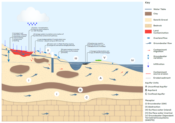
Figure 1: Indicative CSM considerations based on a climatic shift to ‘wetter’ weather.
Future climate change could foreseeably affect any given CSM. For example, an increase in precipitation could lead to increased recharge resulting in rising groundwater levels; source (e.g. soil) erosion; or overland flow. It can further be seen how these scenarios could affect the pathways from source to receptors e.g. unsaturated zone thickness, hydraulic gradients and dilution factors, or the introduction of new pathways e.g. from overland flow, or previously unsaturated drains/culverts acting as new preferential pathways (see Figure 1). As a result of the change in pathway, the number and type of receptors may also be affected, all of which could change the calculated ‘risk’ posed to controlled waters[7].
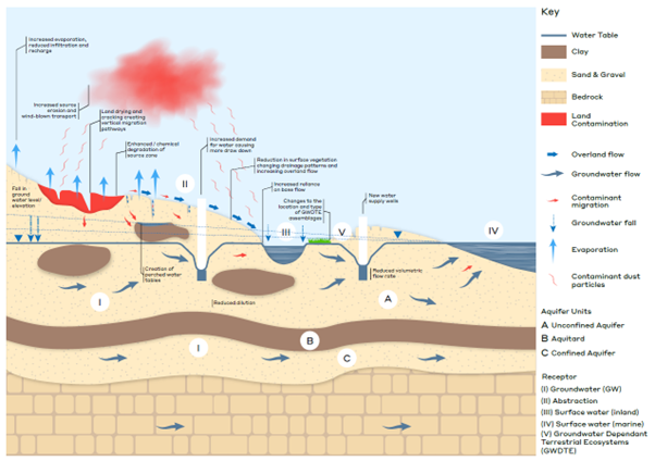
Figure 2: Indicative CSM considerations based on a climatic shift to ‘drier’ weather.
By way of another example, an increase in extended periods of hot dry weather or drought i.e. as predicted for the summer months, could result in reduced overland flow; falling groundwater levels which could, for example, change the pathway length by increasing the unsaturated zone thickness or increase dependency of baseflow to rivers; source drying increasing the risk of wind erosion/dust generation, and the development of desiccation cracks creating preferential vertical flow paths; changes in water demand e.g. through the installation of new abstraction wells or enhanced drawdown. All of which could again alter the calculated ‘risk’ posed to controlled waters (see Figure 2).
In line with industry standards (e.g. LCRM[8]), the SoBRA guidance recognises that any change to a CSM (due to future climate change effects) must be determined by a suitably qualified and experienced professional, using evidence-based reasoning, and that the risk assessment process should only progress to higher tiers (i.e. generic quantitative and detailed quantitative) if the risk cannot be determined ‘acceptable’ at the preliminary stage. The SoBRA guidance supports practitioners in doing this by setting out “What-if” scenarios for source, pathway, receptor CSM components that could be affected by climate change, in order to guide evidence-based reasoning. This is in line with the approach detailed in BS21365.
Adequacy of Available Datasets
The current best source of information for understanding future meteorological (e.g. temperature and precipitation) and sea level rise projections is the Met Office UK Climate Projection (CP) 18[9] dataset. This dataset was primarily developed to inform water resource management and flood risk assessment and as such the data modelled under the worst case high emissions scenario (RCP 8.5) is the most comprehensive, particularly when considering effects at the local scale. Projections are available until the end of the century. The projections consider average effects and do not necessarily include the effects of extreme events.
The Enhanced Future Flows and Groundwater[10] (eFLaG) Project, which is based on UKCP18 meteorological data, is the most up to date source of information detailing projections to recharge and river flows. This may be a more useful data source in relation to understanding changes to the hydrogeological CSM in relation to future climate change.
The choice of data set used to understand future climate change influences on the CSM is ultimately the responsibility of the risk assessor and should be suitably justified with uncertainties and limitations clearly stated. As the effects of climate change vary seasonally and spatially across the UK, careful consideration should be given to the site setting when choosing the appropriate climate model output for use in risk assessment.
Adequacy of Available Modelling Tools
Commercial modelling tools used in the higher tiers of risk assessment e.g. the Remedial Targets Methodology worksheet (‘P20’)[11], and ConSim[12], currently assume environmental conditions remain constant, however, the effects of future climate change are projected to vary over time, and so therefore will the established pollutant linkages.
This poses a challenge for practitioners with tools ill-equipped to model changes to the values of parameters over time. Although distributed flow models exist (e.g. MODFLOW and FEFLOW), in addition to compartmental modelling environments (e.g. ConSim), the data requirements, time, and computational and staff resources required to develop and run these models is unlikely to be proportionate to most routine land contamination risk assessments.
It is therefore evident that further tools need to be developed (or current tools adapted) to model the transient effects of future climate change. However, until such time, the SoBRA guidance recommends that existing tools are employed, except where risks are borderline acceptable (in which case an existing transient modelling approach may be most appropriate). The SoBRA guidance sets out recommendations for how this can be achieved using commercially available tools.
SoBRA Sub-Committee Members
David Drury (Golder Associates / WSP); Emma Evans (Arcadis); Emma Hipkins (Golder Associates / WSP); Emma Khadun (The LK Group); Helen McMillan (RSK Geosciences); Isla Smail (The Scottish Environment Protection Agency); James Wilson (Atkins); Jesse Davies (Ramboll); Jonathon Atkinson (The Environment Agency); Katie Gamlin (WSP); Leon Warrington (Hydrock); Roisin Lindsay (WSP); Sarah Poulton (Natural Resources Wales); and Suzanne Blackman (Mott MacDonald).
We would also like to thank Simon Cole (SoBRA chair) and the wider SoBRA Executive Committee for their support and contributions in making this guidance possible.
[1] https://sobra.org.uk/
[2] UK Climate Projections: Headline Findings. July 2021 (available at https://www.metoffice.gov.uk). Values presented are based on Met Office high emissions projections (RCP8.5) for 10% and 90% probability levels.
[3] Where a negative value denotes a reduction in precipitation.
[4] UKCP18 Climate Change Over Land (available at https://www.metoffice.gov.uk).
[5] Controlled waters is a term used in legislation in England and Wales. Its equivalent in Scotland is the water environment. It is understood that Northern Ireland use both terms. Throughout this article the term ‘controlled waters’ is used to refer to regulated groundwater and surface water throughout the UK.
[6] BS EN ISO 21365:2020 Soil quality – conceptual site models for potentially contaminated sites
[7] Changes to a Conceptual Site Model can also be envisaged because of increases in the frequency and duration of extreme cold weather events, changes to wind intensity and duration, pluvial or groundwater flooding, marine inundation, and river or coastal erosion.
[8] Land Contamination Risk Management Guidance. Available at https://www.gov.uk/government/publications/land-contamination-risk-management-lcrm
[9] https://www.metoffice.gov.uk/research/approach/collaboration/ukcp
[10] https://www.ceh.ac.uk/our-science/projects/eflag-enhanced-future-flows-and-groundwater
[11] https://www.gov.uk/government/publications/remedial-targets-worksheet-v22a-user-manual
[12] http://www.consim.co.uk/
Article provided by Dr. Emma Hipkins, Helen McMillan, and Isla Smail on behalf of the wider SoBRA Climate Change and Controlled Waters sub-group.