Prepared by:
Blaise Hodges, Senior Land Surveyor, Cognition Land and Water, blaise.hodges@cognitionltd.com
Andy O’Dea, Technical Director, Cognition Land and Water, andy.odea@cognitionltd.com
Drones (Unmanned Aerial Vehicles – UAVs) are quickly becoming one of the most useful tools on a typical construction site, offering rapid data collection for topographical surveys or site 4D imagery. Drone arial footage and 4D model mock-ups allow quick access to valuable site data and visual information. Whether it’s for initial site pricing strategies, refining pre-design processes or recording work progress, our investment in drone technology is allowing our teams to work safer and more efficiently, whilst delivering tangible benefits for our clients.
As our drone uses GPS and obstacle avoidance systems, it can be programmed and manoeuvred accurately to precise locations on site and follow pre-determined flight paths. This creates an extremely valuable and multi-faceted tool that can be used in a variety of situations. Such tools and facilities have had a big impact on our work, primarily in the management of earthworks projects. Outlined below are a number of ways in which the application of drone technology and surveying techniques have delivered significant benefits, efficiencies and improvements in data capture and delivery on our projects.
Faster and more accurate site surveys
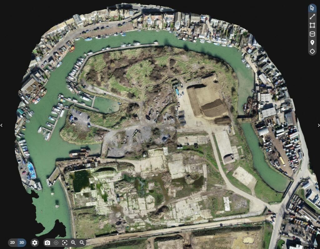
For most surveyors/engineers, there are two simple reasons for using drones for earthworks – speed and accuracy. With conventional land-based surveying techniques, it can take many hours to walk the site and measure aggregates and stockpiles. Subsequently, it often takes several days to process the data and deliver the required volumetric analysis or drawings. Drone surveys allow all of this work to be done in a fraction of the time.
As an example, our Senior Land Surveyor recently carried out a drone survey of a large construction site in less than 20 minutes to collect data on earthworks stockpiles. It was not possible to carry out the survey with traditional ground-based systems due to soft and overgrown ground conditions. The post-survey processing took a matter of hours, despite handling thousands rather than scores of surveyed points across the site surfaces. In addition to the very significant time saving, the far greater number of survey points provides scope for many more outputs such as an orthomosaic point cloud and a 4D digital terrain model (DTM) of the site.
Using proprietary Pix4D software, access to the survey model can be provided to the client and project team via a simple web link. This then allows the whole project team to inspect, manipulate and interrogate the model as well as access to high resolution images, on screen visuals and tools to measure terrain dimensions, etc. Stockpile volumes can be calculated, distances and areas measured, and OS co-ordinates given – all with a few mouse clicks. It is a truly powerful data and imagery presentation system that is accessible to all.
Performing cut-and-fill volumetric analysis
We often utilise traditional GPS surveying in tandem with drone surveys to extract the best of both approaches. Traditional ground-based surveying is used for key site features such as bottom of banks, edges showing changes of surfaces and heights. The drone data collection is then carried out on a grid throughout remaining areas, eliminating the risks associated with climbing stockpiles and providing truly accurate data.
Drones have dramatically reduced the manual work needed to perform a cut-and-fill volumetric analysis following the site survey. Once the aerial data is collected, drone software platforms like Pix4D enables cloud processing and final export into Autodesk file formats like a DXF or a point cloud file that can be used in Civil 3D or LSS design software.
This has allowed us to streamline our cut-and-fill workflow, speeding up the process significantly. We have estimated that we can now carry out volumetric analysis and cut and fill calculations in about one-third the time it took us previously. This provides cost savings to our clients and greater time to interrogate the output of the analysis and formulate innovative and novel solutions to the ground engineering problems presented to us.
Verifying work and managing conflicts
During the course of an earthworks project, it is vital to regularly monitor progress, especially at key milestones, to ensure the works are progressing to programme. Drone surveys have become an invaluable tool in this monitoring and verification process.
We fly our sites as often as is required by the project to satisfactorily record progress. We then process the images into an orthomosaic, and hence into an elevation map that can be compared to the initial site plans as the project progresses. This allows for clear and robust recording and monitoring at important phases of the project. Importantly, this information enables more focused quality control as well as providing site managers with detailed information on progress to allow closer and more accurate management of resources and expenditure. Such interim surveys also provide robust data for interim works measurement and payment applications.
Site inspections and tender support
We will often use drone surveys in support of our tender and estimating work. A quick drone survey carried out at the tender stage can provide invaluable information to both the client and contractor on the site conditions, building (current and former) footprints, topography, site restrictions, earthworks volumes, building condition, etc.
Drones can capture images and videos, allowing for detailed mapping and easy access to inspect and prepare volumetric data for cut and fill calculations. Gathering information through a single drone survey allows for a far better understanding of the key project risks, makes the costings on a project more accurate and saves significant time in the tender stage by avoiding multiple site visits.
The speed at which we can now perform quite complex and detailed imaging, topographic and volumetric surveys means that we will often provide our initial drone survey as a free service to our clients at the tender stage, giving us a clear advantage and differentiator against our competition.
Improved worker safety
In the field, surveyors and engineers spend hours on the ground collecting data or overseeing site-based work. This is not only time-consuming but can be deemed as a risky activity. Often, site rules or risk assessments will not allow personnel to access stockpiles or move freely around the site due to plant movement and other site risks. Traversing steep slopes that are uneven and potentially unstable is an activity fraught with dangers. This can all be avoided by the use of a drone survey. Site engineers and personnel can inspect and quantify the site, earthworks, slopes and stockpiles from a safe distance avoiding all associated trip and fall hazards.
To assist with communicating key site risks to the workforce, a drone aerial photography survey will allow for a good overall representation of the site and help provide powerful visual information to site managers for use in site inductions or toolbox talks. Drone surveys may even be used to conduct safety inspections or audits at large sites and this is something that we are looking to introduce shortly.
A powerful tool
We hope that the examples provided above give a flavour for the powerful benefits that drone surveys have made at our company and how investment in this technology has revolutionised the way in which we inspect, manage, record and report the work we do. It is fair to say that it have been a game-changer for Cognition Land and Water and we would be happy to share our experiences with you further if that would be helpful.
Cognition Land and Water is a specialist ground engineering and contamination remediation contractor with the capability to deliver all ground-related aspects of construction projects from site investigations, remediation, earthworks and ground engineering, through to civil engineering and concrete-framed structures.